[ 1774 ] - [ 1860]
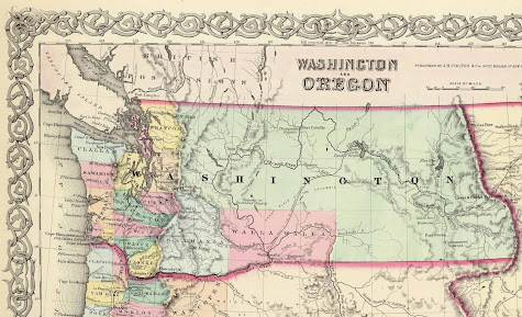
WA Territory to State to King County
First European record of a landing on Washington coast: 1774 by Spanish explorer Juan José Pérez Hernández. During mission traded with Haida people.
|
1790
Spanish-British treaties of Nootka Conventions ended Spanish exclusivity and opened the Northwest Coast.
|
1792
British Royal Navy Captain George Vancouver (1757-1798) claimed the sound and coast for Britain and named the waters originally to the far south of the Tacoma Narrows as the Puget's Sound, in honor of Peter Puget (1765-1822)
1800's
Treaty of 1818
Following the War of 1812 (1812-1815), Great Britain and the United States established 49th parallel as international border, stretching west to the Continental Divide of the Rocky Mountains; Both agreed temporary joint control and occupancy of Oregon Country / Columbia District for next few years. At the time, the U.S. shared this territory with the British, Spanish and Russians.
|
1833
Fort Nisqually, built in the South Puget Sound area by the Hudson’s Bay Company in 1833
|
1841
 |
| Charles Wilkes. “Map of the Oregon Territory.” 1841. |
1845
 |
| Counties in Washington, 1845 |
1846
The United Kingdom and the United States agreed to the Oregon Treaty in 1846, establishing the British-American boundary at the 49th parallel (except Vancouver Island).
The area of original Oregon Country lies within present-day borders of the Canadian province of British Columbia and the entirety of the U.S. states of Oregon, Washington, and Idaho, as well as parts of Montana and Wyoming.
|
1848
 |
| Map of Oregon Territory, 1848 |
|
1850
Congress passed a measure that provided similarly generous land grants to current residents of the territory.
Donation Land Claim Act allowed married women to claim land with their husbands. Under provisions of the law, every male settler over the age of 18 who had occupied land for four years before 1850 could claim 320 acres, and the wives of these men had the right to obtain an equal amount.
Individuals who settled after December 1849, but before December 1853, could each claim 160 acres. Congress later extended the provisions of the Donation Land Claim Act to settlers arriving as late as 1855.
|
1852
November 25th, 1852
Settlers from Cowlitz / Puget Sound regions met at "Monticello Convention" in present-day Longview to draft a petition to the United States Congress calling for a separate territory north of the Columbia River.
|
December 22nd, 1852
King County was formed out of territory within larger Thurston County by the Oregon Territory legislature.
King County was named for William Rufus DeVane King, a Democratic senator from Alabama elected U.S. vice president the year of his death in April of 1853.
King, pre-civil war, owned slaves and supported a pro-slavery position, arguing the US Constitution protected the institution of slavery in both Southern states and federal territories.
|
1853
January 11th, 1853
Seattle was made "county seat"
Bill to establish Washington Territory (H.R. 348) was reported in the U.S. House of Representatives during the 32nd United States Congress.
|
March 2nd 1853
Signed by President Millard Fillmore, the Territory of Washington was an organized incorporated territory of the United States.
|
|
|
1855
The Puget Sound War was an armed conflict that took place in the Puget Sound area of the state of Washington in 1855–56, between the United States military, local militias and members of the Native American tribes of the Nisqually, Muckleshoot, Puyallup, and Klickitat.
Another component of the war, however, were raiders from the Haida and Tlingit who came into conflict with the United States Navy during contemporaneous raids on the native peoples of Puget Sound. Although limited in its magnitude, territorial impact and losses in terms of lives, the conflict is often remembered in connection to the 1856 Battle of Seattle and to the execution of a central figure of the war, Nisqually Chief Leschi.
Treaty of Point Elliott was signed in Washington Territory, and established a government-to-government relationship between the United States and various Coast Salish nations, including the Duwamish, Suquamish, and Snoqualmie, ceding land in exchange for reservations and guaranteed rights to hunt, fish, and gather. https://goia.wa.gov/tribal-government/treaty-point-elliott-1855
|
|
1856
 |
| Land Survey, 25N 4E, SEC 13/24/25/36, partial land outcropping of Bellevue / Medina area, East Lake WA |
|
1857
 |
| Map from 1857 showing the names of Native American groups in the general vicinity of King County (above) |
 |
| 1857 Table of WA/King County tribal populations and reservations |
|
1859
 |
| 1859 Map showing the routes of the Naches, Cowlitz, and Oregon Trails. |


No comments:
Post a Comment